
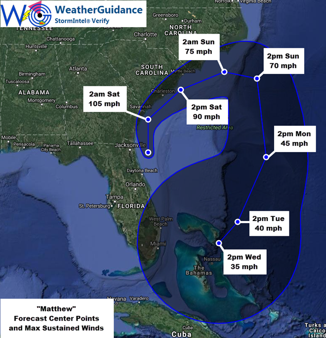
At 5:00 pm EDT this afternoon the center of Hurricane Matthew was located approximately 40 miles to the East of Jacksonville Beach, FL. Matthew was moving in a general Northerly direction at near 12 mph. Maximum sustained winds were near 110 mph (mainly to the East of the center over water) . The minimum central pressure was 948 mb/28.00 inches of mercury.
The center of Hurricane Matthew will likely continue to move toward the North tonight and then turn more toward the Northeast during the pre-dawn and early morning hours of Saturday, on into the daytime hours on Saturday. With this projected track in mind, the highest winds associated with Matthew will likely continue to remain just barely offshore along and to the East of the center of the system through Saturday.
…Wind Impacts for Florida Will Gradually Diminish this Evening – Flooding to Continue Some Areas into Tonight…
Impacts from wind will continue to diminish across Florida this evening. Most tropical storm force winds will end across far northeastern Florida (especially in the Jacksonville area) from South to North between now and late this evening. Elsewhere, gusty winds below tropical storm force will continue in east-central and northeast Florida through Sunset, then gradually diminish from South to North.
Locally heavy rainfall will continue at times this evening especially in the far northeastern corner of the state. Higher than normal surf and wave action along with dangerous rip currents will continue across much of the east-central and northeastern Florida coastline through tonight.
Flooding of low lying areas will continue especially near times of high tide across far northeastern Florida tonight. Standing water will also remain in many low lying areas that experienced flooding earlier today (or are presently experiencing such conditions).
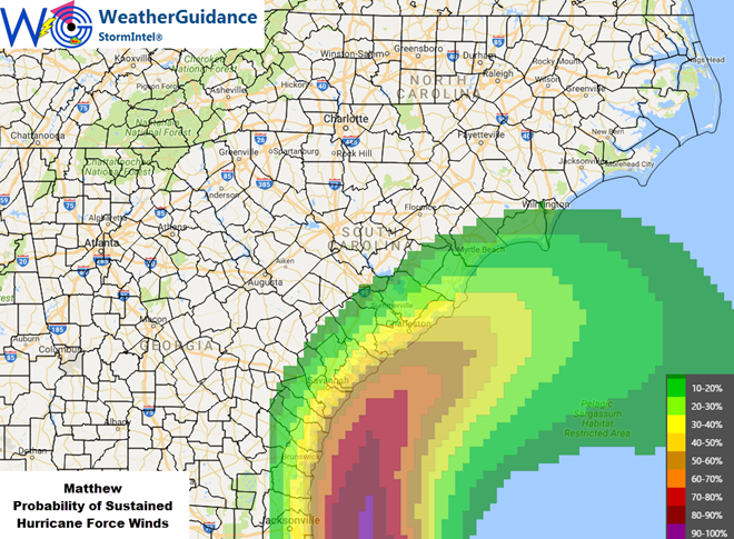
…Expected Impacts for Georgia and the Carolinas Later Today into This Weekend…
The center of Matthew is likely to remain just offshore to the East of Georgia through tonight, and to the South of the Carolinas on Saturday (South Carolina) into Sunday (North Carolina). This track will likely continue to keep the highest winds and wind related impacts offshore away from land, with mainly Tropical Storm force winds inland:
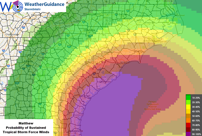
The primary risk for hurricane force winds in the Georgia/Carolinas region will be in the form of gusts, and especially along the immediate shoreline in Georgia tonight and in South Carolina later tonight into Saturday. This includes the Charleston area which appears most vulnerable to potential hurricane force winds (especially gusts) later tonight and into early Saturday:
Due to the angle of arrival and forecast movement of Matthew, storm surge flooding will mainly 1-3 foot levels as shown in light blue below, and some 3-6 foot levels possible as shown in yellow. The primary risk of storm surge flooding in these areas will be near the time of high tide in Georgia today/tonight and in the Carolinas over the weekend:
Locally heavy rainfall of around 6 inches is likely with localized higher amounts possible in the southeast Georgia/Carolinas region in association with Matthew. Isolated tornadoes are also possible in this same region as stronger thunderstorms rotate around Matthew.
…Outlook Beyond This Weekend…
Matthew is forecast to turn back toward the East and then South into early next week, meandering over the area generally to the East of Florida and to the North of the Bahamas through mid-week, likely as a weak tropical storm or tropical depression by that time. There are no additional land impacts expected through Wednesday at this time. Higher than normal surf and wave action can be expected again along the Eastern coast of Florida especially on Tuesday and Wednesday as the system recurves.